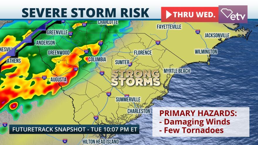
A system prompting Tornado Watches in the Deep South Tuesday afternoon could bring damaging winds and tornadoes to the Palmetto State through Wednesday.
Surface analysis Tuesday afternoon depicts a large area of low pressure centered in the Upper Midwest. In the warm sector of the low, temperatures and dew points are well above average across the Southeast. The warm and unstable air mass ahead of an approaching cold front will provide extra lift in the atmosphere across the Palmetto State. Strong storms are expected to continue developing into a broken line Tuesday into Wednesday, bringing the risk of damaging winds and even a few tornadoes to the state.
High-resolution weather models indicate the most instability will be found across the Midlands, Lowcountry, and Pee Dee. Two distinct rounds of strong thunderstorms appear likely Tuesday night through Wednesday. The first round is expected to bring the risk of damaging winds to the Upstate and portions of the Midlands Tuesday night. As instability wanes overnight Tuesday, the risk of severe weather will diminish somewhat. As the cold front approaches the state from the west Wednesday, a broken line of thunderstorms will move through. This main line along the cold front will likely arrive in the Upstate first around daybreak Wednesday, with storms arriving in the state capital by midday. From there, the cold front should push storms through the Lowcountry and offshore by Wednesday evening.
The Storm Prediction Center has a "marginal" risk for severe weather in the Upstate through Wednesday morning and across the entire state through Wednesday evening. These classifications represent a 1 on a severe weather scale of 1-to-5 and mean that a few widely scattered severe thunderstorms are possible. While storms are expected to undergo a gradual weakening trend, damaging winds of up to 60 miles per hour are possible. The upper-level wind pattern does also suggest a few tornadoes are possible.
There is the potential for watches and warnings to be issued through Wednesday. If a watch is issued, it means that the ingredients for severe weather or tornadoes are present in the atmosphere. Watches are typically issued before the weather turns severe and tend to cover a fairly large geographic area for several hours. A warning on the other hand is issued when severe weather is ongoing for a specific location and is typically on a smaller geographic scale, typically covering only a few counties at a time. Warnings generally last an hour or less in any given location. Residents are encouraged to have multiple ways to receive severe weather alerts and to keep a close eye on the forecast over the next 24 hours.


