

Nicole is forecast to move into South Carolina by late week and will bring gusty winds, a flash flood risk, and the potential for a few tornadoes.
Tropical storm warnings are in effect for portions of the Lowcountry, including cities like Charleston and Beaufort. Storm surge warnings stretch from the mouth of the South Santee River to the South Carolina-Georgia border, while coastal flood advisories stretch along the Grand Strand. A wind advisory is in place for much of the state west of I-95 in lieu of tropical storm watches or warnings. Gusts in the wind advisory area could reach 40 miles per hour Thursday night through much of Friday.
Category 1 Hurricane Nicole made landfall near Vero Beach, Florida, early Thursday morning, with estimated sustained maximum wind speeds of 75 miles per hour.
3 AM EST Update: Hurricane #Nicole has made landfall along the east coast of Florida just south of Vero Beach. This will be the last hourly update on Nicole. For the latest info: https://t.co/tW4KeGe9uJ pic.twitter.com/9IGix0mUU1
— National Hurricane Center (@NHC_Atlantic) November 10, 2022
After spending several hours over land, the National Hurricane Center's latest advisory estimates maximum sustained winds within Nicole of 60 miles per hour, making Nicole a tropical storm. Nicole will push through Florida through Thursday afternoon before potentially making a second landfall in the Panhandle Thursday evening. Whether Nicole makes a second Florida landfall or not, the official forecast brings Tropical Storm Nicole into southwest Georgia early Friday morning. By Friday afternoon, Nicole is expected to gradually weaken into a depression as it moves into the Upstate.
Model guidance suggests widespread and at times heavy rainfall will reach the Lowcountry by Thursday evening, spreading into the Midlands during the overnight hours. An inch or two of rain is possible out of this first round of rainbands through Friday morning, but a lull in activity during the midday hours Friday will provide a brief reprieve for many. As the low-level circulation supporting Nicole inches closer by Friday afternoon, a resurgence of shower and thunderstorm activity is possible. A final round of storms will likely push through the state Friday evening as a strong cold front provides support in getting remnants of Nicole out of the Palmetto State.
Impacts from Nicole's remnants will include widespread wind gusts of up to tropical-storm-force, the risk of flash flooding, isolated tornadoes, and storm surge and coastal erosion. Wind gusts of at least 40 miles per hour will be possible across the Lowcountry starting late Thursday morning. Gusty winds will overspread much of the Palmetto State by early Friday morning, as rain bands push through the Midlands and Pee Dee. Breezy conditions will coincide with heavy rainfall, meaning the flash flood risk will be highest through Thursday night across the Lowcountry. The risk area for flash flooding will be present through Friday, but the area most prone to flash flooding will shift toward the higher elevations of the Upstate.
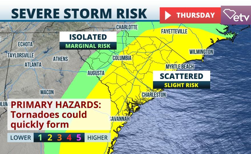
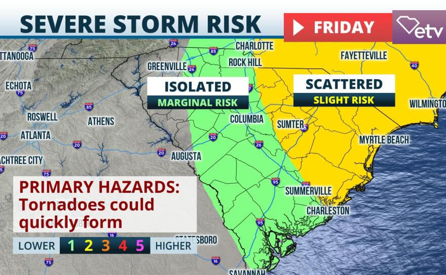
As with many landfalling tropical systems, there is a risk for a few quick spin-up tornadoes. The Storm Prediction Center has the eastern half of the state under a "slight" risk of severe weather Thursday, which is a 2 on a scale of 1-to-5. By Friday, this risk area is forecast to shift northeast toward the Pee Dee. While tropical tornadoes tend to be weaker in nature, they can develop with little to no advance notice. It is important for residents to have more than one way to receive weather alerts and if warnings are issued in your area, seek shelter immediately. The risk of tornadoes will be most likely Thursday night across the southern Midlands and Lowcountry, where instability will be most readily available for cells to tap into. The threat for tornadoes will gradually diminish from west to east through the day Friday, meaning the Grand Strand area will likely hold onto the tornado threat through Friday night.
Following the cold frontal passage that will pick up Nicole's remnants, a much quieter weekend is anticipated. A significantly colder air mass will move into the Palmetto State by Sunday, with highs in many areas likely not getting out of the 50s.