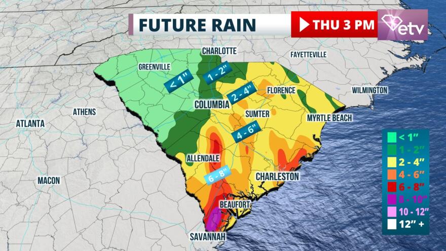
Update 11:00 PM Wednesday: Heavy rain bands on the east side of Tropical Storm Elsa were noted on radar to be spreading across the LowCountry late Wednesday evening. The tornado risk will be increasing as these bands rotate in overnight, where a Tornado Watch continues for the area until 5 am Thursday.
Update as of 12:15 PM Wednesday:
Elsa made landfall along Florida's Big Bend coast, just west of Steinhatchee River, around 11 o'clock Wednesday morning with top sustained winds of 65 mph. It is moving northward at 14 mph.
A few showers have already made into it Jasper, Beaufort, and Hampton counties in the Lowcountry. The more significant bands will hold off until around dusk Wednesday. Heavier rain bands will move in over the state from the Midlands to the coast overnight Wednesday.
Original Story from 3:15 AM Wednesday:
Tropical Storm Warnings are in effect for the entire South Carolina coastline as Tropical Storm Elsa makes its move toward the state later Wednesday into Thursday. Flooding from heavy rain and isolated tornadoes are likely to be the primary hazards from the approaching storm.
Tropical Storm Elsa briefly attained hurricane status in the Gulf southwest of Tampa Tuesday evening, but is a tropical storm once again in the Gulf prior to landfall in the Florida Big Bend Wednesday morning. Wind gusts around 60 mph were observed in Key West Tuesday morning and gusts between 40 and 50 mph have been observed as of early Wednesday morning in the Tampa/St. Petersburg metropolitan area. Radar and rain gauge data suggest 5 to 10 inches of rain has fallen over a large portion of the western Florida Peninsula.

Once the storm makes landfall in the Big Bend Wednesday morning, Elsa will move northeastward and accelerate toward South Carolina. The first rain bands are expected to arrive in the Lowcountry early Wednesday evening, about the same time tropical storm force winds are possible. Brief gusts to around 40 mph are likely within the Tropical Storm Warning area near the coastal counties. These winds and rain will spread northward overnight and reach the border with North Carolina around dawn Thursday.

Rainfall amounts of 3 to 5 inches are possible over much of the state, particularly from the Midlands eastward to the coast. A few places may see amounts in excess of 8 inches. However, a small shift to the west in the latest track may also bring a period of heavy rain as far west as the Greenville and Spartanburg areas for a time early Thursday morning. These rains are capable of considerable flash flooding and urban flooding.
Isolated tornadoes are possible across the eastern half of the state Wednesday night into Thursday morning. Water levels may rise 1 to 2 feet above normally dry ground in some sensitive areas near the immediate coast.
A few rain bands are likely to continue as late as Thursday evening in parts of the Pee Dee and Grand Strand areas, but the worst of the weather is expected to end on Thursday night when the storm moves into North Carolina.


