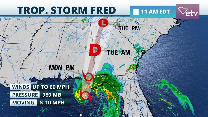
Tropical Storm Fred was intensifying Monday on approach to landfall in the Florida Panhandle Monday evening. Its outer rain bands are likely to bring heavy rain and the possibility of isolated tornadoes on Tuesday to a portion of the Palmetto state.
Tropical Storm and Storm Surge Warnings were in effect for much of the Florida Panhandle and Big Bend. Flash flooding, rip currents, coastal flooding, and upward of 3 to 5 feet of surge were possible in a portion of the Big Bend area later Monday into Monday night. The storm's structure on radar was improving Monday morning and reports from Hurricane Hunter Aircraft indicate that Fred was intensifying on its approach to Florida.

The center of the storm is forecast to pass over Georgia on Tuesday. Moisture well ahead of Fred will contribute to scattered to numerous showers and thunderstorms statewide Monday into Monday night. Rain from some of Fred's outer bands could be near the Central Savannah River Area Tuesday morning. Daytime heating and unstable air should cause these bands to intensify as they move across the Upstate and Midlands Tuesday afternoon and evening. Rainfall amounts of 4 to 7 inches are possible, especially over the Upstate region. Isolated amounts may reach 10 inches, particularly near higher terrain or where persistent bands set up. If realized, this amount of rain is capable of producing flash flooding.
Widespread tornadoes are not forecast, but a brief, isolated tornado or two is possible in association with some of the outer bands in the Upstate or Midlands Tuesday afternoon during peak heating. Bands will tend to diminish after sunset Tuesday evening when the air stabilizes and Fred moves farther north into the central Appalachians.

Tropical Depression Grace is passing near the south coast of Haiti Monday afternoon. Its more southward track means less interaction with the mountainous island of Hispaniola is more probable. For that reason, it could gain tropical storm status in the western Caribbean by Wednesday on its way to Mexico's Yucatan Peninsula and southern Gulf of Mexico Thursday and Friday. Grace is not expected to impact South Carolina.

Finally, Tropical Depression 8 developed late Sunday not far from Bermuda. It is forecast to become Tropical Storm Henri Monday afternoon. A Tropical Storm Watch is in effect for the island with the center of the storm expected to pass south and then west of the island during this week. The latest forecast track keeps the storm well offshore of the Carolinas through Friday, but residents should monitor the forecast for possible changes later this week as the storm strengthens.


