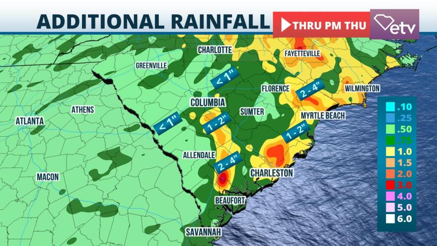
More than 10 inches of rain have fallen in parts of South Carolina's Lowcountry since late Sunday, and additional heavy rain is expected to maintain or heighten the flash flood risk through Tuesday evening.
Deep, rich tropical moisture is focused over the eastern third of the state, where Flash Flood Watches remain in effect through Tuesday evening. A separate area of potential flash flooding is located over the higher terrain of Oconee, Pickens, and Greenville counties, which are also under Flash Flood Watches.
Widespread rainfall totals of 2 to 5 inches have already occurred from Charleston county southward into Beaufort and Jasper counties. Local pockets near Hilton Head Island have received over 10 inches since late Sunday based on an analysis of rain gauge and radar data. 1 to 2 inches have fallen over the Upstate west of Interstate 85. These amounts over the hillier terrain, along with additional expected rain on Tuesday, are enough to create conditions favorable for flash flooding.
Impressive rain in South Carolina's #Lowcountry. I see some places in #Beaufort county have exceeded 10 inches the past few days. #scwx #SCETVwx pic.twitter.com/O7YEIacGpS
— Ray Hawthorne (@ray_hawthorne) September 21, 2021
The bands of heavy rain are expected to develop northward into the Grand Strand and inland over the Pee Dee Tuesday into Tuesday night. 2 to 4 inches of rain are possible in these areas, with isolated amounts greater than 5 inches according to the National Weather Service.

The deepest atmospheric moisture will get shoved to the immediate coastline on Wednesday, but an approaching cold front will contribute scattered showers and thunderstorms across the state. The risk of flash flooding is not expected to be as high on Wednesday, but it is still possible in vulnerable areas where additional heavy showers develop.
Much drier air is forecast to move in behind the front statewide on Thursday and lasting into the upcoming weekend. Not only will the drier air feel more comfortable to many, but it will put an end to the flash flooding.


